


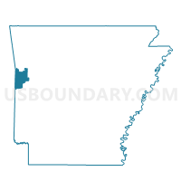
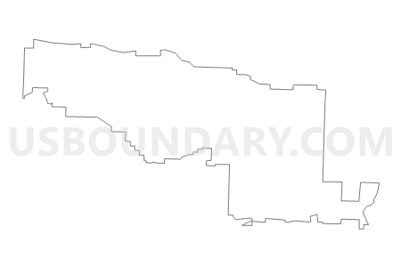
Voting District 9-1-M, Sebastian County, Arkansas
About
Outline

Summary
| Unique Area Identifier | 528170 |
| Name | Voting District 9-1-M |
| County | Sebastian County |
| State | Arkansas |
| Area (square miles) | 92.28 |
| Land Area (square miles) | 91.78 |
| Water Area (square miles) | 0.50 |
| % of Land Area | 99.46 |
| % of Water Area | 0.54 |
| Latitude of the Internal Point | 35.26292730 |
| Longtitude of the Internal Point | -94.19758260 |
Maps


Graphs
Select a template below for downloading or customizing gragh for Voting District 9-1-M, Sebastian County, Arkansas


Neighbors
Neighoring Voting District (by Name) Neighboring Voting District on the Map
- Voting District 3-G, Sebastian County, AR
- Voting District 3-O, Sebastian County, AR
- Voting District 4-F, Sebastian County, AR
- Voting District 4-G, Sebastian County, AR
- Voting District 9-1-C, Sebastian County, AR
- Voting District 9-1-E, Sebastian County, AR
- Voting District 9-1-F, 9-1-G, 9-1-H, Sebastian County, AR
- Voting District 9-1-I, 9-1-J, 9-1-K, Sebastian County, AR
- Voting District 9-1-L, Sebastian County, AR
- Voting District 9-1-N, Sebastian County, AR
- Voting District 9-1-O, Sebastian County, AR
- Voting District 9-1-P, Sebastian County, AR
- Voting District 9-1-Q, Sebastian County, AR
- Voting District 9-2-A, 9-2-B, 9-2-C, Sebastian County, AR
- Voting District 9-2-D, Sebastian County, AR
- Voting District 9-4-H, Sebastian County, AR
- Voting District 9-4-K, Sebastian County, AR
- Voting District 9-6-A, Sebastian County, AR
- Voting District 9-6-B, Sebastian County, AR
- J P Dist 8-C, Franklin County, AR
- Washburn Voting District, Logan County, AR
Top 10 Neighboring County Subdivision (by Population) Neighboring County Subdivision on the Map
- Upper township, Sebastian County, AR (76,938)
- Center township, Sebastian County, AR (10,762)
- Lon Norris township, Sebastian County, AR (8,133)
- Mont Sandels township, Sebastian County, AR (5,151)
- Marion township, Sebastian County, AR (4,689)
- Big Creek township, Sebastian County, AR (3,715)
- Prairie township, Franklin County, AR (3,132)
- Bloomer township, Sebastian County, AR (1,022)
- Rogers township, Sebastian County, AR (946)
- Washburn township, Logan County, AR (821)
Top 10 Neighboring Place (by Population) Neighboring Place on the Map
Top 10 Neighboring Unified School District (by Population) Neighboring Unified School District on the Map
- Fort Smith Public Schools, AR (89,450)
- Greenwood School District, AR (19,838)
- Booneville School District, AR (8,038)
- Lavaca Public Schools, AR (5,013)
- Charleston School District, AR (4,932)
Top 10 Neighboring State Legislative District Lower Chamber (by Population) Neighboring State Legislative District Lower Chamber on the Map
- State House District 63, AR (30,811)
- State House District 67, AR (30,060)
- State House District 62, AR (27,262)
- State House District 84, AR (25,531)
Top 10 Neighboring State Legislative District Upper Chamber (by Population) Neighboring State Legislative District Upper Chamber on the Map
- State Senate District 6, AR (89,072)
- State Senate District 3, AR (87,143)
- State Senate District 13, AR (82,857)
Top 10 Neighboring 111th Congressional District (by Population) Neighboring 111th Congressional District on the Map
Top 10 Neighboring Census Tract (by Population) Neighboring Census Tract on the Map
- Census Tract 13.02, Sebastian County, AR (8,700)
- Census Tract 9503, Franklin County, AR (6,987)
- Census Tract 101.02, Sebastian County, AR (6,327)
- Census Tract 101.01, Sebastian County, AR (6,118)
- Census Tract 102.01, Sebastian County, AR (4,863)
- Census Tract 13.05, Sebastian County, AR (4,718)
- Census Tract 9504, Logan County, AR (3,322)
- Census Tract 11.02, Sebastian County, AR (3,058)
Top 10 Neighboring 5-Digit ZIP Code Tabulation Area (by Population) Neighboring 5-Digit ZIP Code Tabulation Area on the Map
- 72903, AR (26,148)
- 72936, AR (14,527)
- 72927, AR (8,701)
- 72916, AR (7,131)
- 72941, AR (5,251)
- 72933, AR (4,999)
- 72923, AR (4,735)